.

Oil Fields #28, Cold Lake Alberta, Canada: photo by Edward Burtynsky, 2001 (Edward Burtynsky Photographic Works)
The "personal note" rings oddly
discordant, in context
of the ruin
of an actual planet. In the back
seat of a Fifty
Four Olds, somewhere
beyond Windsor -- Andy
Williams singing that
terrible calcified white
man's classic.
Oh no, not again. Turns out the Athabasca
Oil Sands
not unlike that wimpy Ike Era
lyric, were meant
not for Athabascan
Man
but for you
and me
and the nitrogen
uptake of our putative heirs.
Oil Fields #22 Cold Lake, Alberta, Canada: photo by Edward Burtynsky, 2001 (Edward Burtynsky Photographic Works)

Alberta Oil Sands #6, Fort McMurray, Alberta, Canada: photo by Edward Burtynsky, 2007 (Edward Burtynsky Photographic Works)

Alberta Oil Sands #9, Fort McMurray, Alberta, Canada: photo by Edward Burtynsky, 2007 (Edward Burtynsky Photographic Works)

Alberta Oil Sands #7, Fort McMurray, Alberta, Canada: photo by Edward Burtynsky, 2007 (Edward Burtynsky Photographic Works)

Alberta Oil Sands #2, Fort McMurray, Alberta, Canada: photo by Edward Burtynsky, 2007 (Edward Burtynsky Photographic Works)

Alberta Oil Sands #10, Fort McMurray, Alberta, Canada: photo by Edward Burtynsky, 2007 (Edward Burtynsky Photographic Works)

Alberta Oil Sands #8, Fort McMurray, Alberta, Canada: photo by Edward Burtynsky, 2007 (Edward Burtynsky Photographic Works)

Alberta Oil Sands #1, Fort McMurray, Alberta, Canada: photo by Edward Burtynsky, 2007 (Edward Burtynsky Photographic Works)
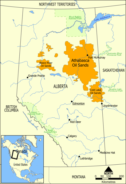
Map showing the extent of the oil sands in Alberta, Canada. The three oil sand deposits are known as the Athabasca Oil Sands, the Cold Lake Oil Sands, and the Peace River Oil Sands: image by Norman Einstein, 10 May 2006
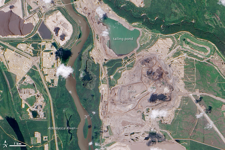
Athabasca oil sands mining field: NASA Earth Observatory image by Jesse Allen and Robert Simmon, acquired 29 July 2009 using EO-1 Advanced Land Rover data courtesy of the NASA EO-I team; caption by Holli Riebeek (NASA)
In the ranking of the world’s proven oil reserves, Canada stands behind only Saudi Arabia. Canada possesses an estimated 178.6 billion barrels of crude oil accessible using current technology. Of this reserve, 174 billion barrels are in Alberta’s oil sand fields, which cover 140,200 square kilometers (54,132 square miles) of the province. The largest oil sand field is Athabasca, shown here.
Oil sands consist of sand coated in water and a sticky film of bitumen, a heavy oil. The bitumen can be rinsed from the sand and refined into fuels. In some cases, the bitumen-encased sand can be pumped from wells like standard oil, but in Athabasca, the sands are at or near the surface. Here, oil companies scoop the sand from the surface after stripping off overlying vegetation and top soil. The result is illustrated in this true-color image. Earthy open-pit mines and muddy tailing ponds replaced the dark green boreal forest.
The mines follow the course of the Athabasca River, the dark brown ribbon of water that runs down the center of the image. The river is essential to the operation. Over the course of its very long lifetime, the river has eroded through the sediment that once covered the oil deposit, gradually bringing it close to the surface. Without the river, the oil sands would likely be buried beneath a thick layer of earth.
The river is also key to the mining process. To separate the bitumen from the sand, refineries bathe the sands in hot water. The contaminated water cannot be returned to the Athabasca River, from which it was drawn, and it ends up in tailing ponds, visible in the image. The tailing ponds are one of the environmental risks of these mines. The ponds replace natural wetlands and because they contain toxic chemicals, they are a threat to wildlife. In April 2008, hundreds of migrating ducks died after landing on a tailing pond, said news reports. Local residents worry that the toxic water may be leaking into the ground water or the Athabasca River, which, as the image illustrates, is very near many of the ponds.

Athabasca Oil Sands: satellite image by NASA Earth Observatory, 23 July 1984 (NASA)

Athabasca Oil Sands: satellite image by NASA Earth Observatory, 28 September 1985 (NASA)

Athabasca Oil Sands: satellite image by NASA Earth Observatory, 14 August 1986 (NASA)

Athabasca Oil Sands: satellite image by NASA Earth Observatory, 18 September 1987 (NASA)

Athabasca Oil Sands: satellite image by NASA Earth Observatory, 4 September 1988 (NASA)

Athabasca Oil Sands: satellite image by NASA Earth Observatory, 6 August 1989 (NASA)

Athabasca Oil Sands: satellite image by NASA Earth Observatory, 24 July 1990 (NASA)

Athabasca Oil Sands: satellite image by NASA Earth Observatory, 27 July 1991 (NASA)

Athabasca Oil Sands: satellite image by NASA Earth Observatory, 13 July 1992 (NASA)

Athabasca Oil Sands: satellite image by NASA Earth Observatory, 17 August 1993 (NASA)

Athabasca Oil Sands: satellite image by NASA Earth Observatory, 26 July 1994 (NASA)

Athabasca Oil Sands: satellite image by NASA Earth Observatory, 24 September 1995 (NASA)

Athabasca Oil Sands: satellite image by NASA Earth Observatory, 22 June 1996 (NASA)

Athabasca Oil Sands: satellite image by NASA Earth Observatory, 12 August 1997 (NASA)

Athabasca Oil Sands: satellite image by NASA Earth Observatory, 5 July 1998 (NASA)

Athabasca Oil Sands: satellite image by NASA Earth Observatory, 15 June 1999 (NASA)

Athabasca Oil Sands: satellite image by NASA Earth Observatory, 13 September 2000 (NASA)

Athabasca Oil Sands: satellite image by NASA Earth Observatory, 7 August 2001 (NASA)

Athabasca Oil Sands: satellite image by NASA Earth Observatory, 11 September 2002 (NASA)

Athabasca Oil Sands: satellite image by NASA Earth Observatory, 30 September 2003 (NASA)

Athabasca Oil Sands: satellite image by NASA Earth Observatory, 28 June 2004 (NASA)

Athabasca Oil Sands: satellite image by NASA Earth Observatory, 5 October 2005 (NASA)

Athabasca Oil Sands: satellite image by NASA Earth Observatory, 21 August 2006 (NASA)

Athabasca Oil Sands: satellite image by NASA Earth Observatory, 30 July 2007 (NASA)

Athabasca Oil Sands: satellite image by NASA Earth Observatory, 25 July 2008 (NASA)

Athabasca Oil Sands: satellite image by NASA Earth Observatory, 14 September 2009 (NASA)

Athabasca Oil Sands: satellite image by NASA Earth Observatory, 3 October 2010 (NASA)

Athabasca Oil Sands: satellite image by NASA Earth Observatory, 15 May 2011 (NASA)
Buried under Canada’s boreal forest is one of the world’s largest reserves of oil. Bitumen—a very thick and heavy form of oil (also called asphalt) -- coats grains of sand and other minerals in a deposit that covers about 142,200 square kilometers (54,900 square miles) of northwest Alberta. According to a 2003 estimate, Alberta has the capacity to produce 174.5 billion barrels of oil. Only 20 percent of the oil sands lie near the surface where they can easily be mined, and these deposits flank the Athabasca River. The rest of the oil sands are buried more than 75 meters below ground and are extracted by injecting hot water into a well that liquefies the oil for pumping. In 2010, surface mines produced 356.99 million barrels of crude oil, while in situ production (the hot water wells) yielded 189.41 million barrels of oil.
This series of images from the Landsat satellite shows the growth of surface mines over the Athabasca oil sands between 1984 and 2011. The Athabasca River runs through the center of the scene, separating two major operations. To extract the oil at these locations, oil producers remove the sand in big, open-pit mines, which are tan and irregularly shaped. The sand is rinsed with hot water to separate the oil, and then the sand and wastewater are stored in "tailings ponds,” which have smooth tan or green surfaces in satellite images.
The process of extracting oil from the sand is expensive. It takes two tons of sand to produce one barrel of crude oil. Great Canadian Oil Sands opened the first large-scale mine in 1967, but growth was slow until 2000 because the global cost of a barrel of oil was too low to make oil sands profitable.
The images above show slow growth between 1984 and 2000, followed by a decade of more rapid development. The first mine (from 1967, now part of the Millennium Mine) is visible near the Athabasca River in the 1984 image. The only new development visible between 1984 and 2000 is the Mildred Lake Mine (west of the river), which began production in 1996.
After 2000, the price of oil began to climb, and investment in oil sands became profitable. The Millennium Mine expanded east of the Athabasca River, and the Steepbank Mine was developed in the east. The Mildred Lake Mine also shows evidence of growth. It is a trend that is likely to continue since permits have been approved to expand mines in this region. The large images include a view of additional mines developing to the north.
Oil sand mining has a large impact on the environment. Forests must be cleared for both open-pit and in situ mining. Pit mines can grow to more than 80 meters depth, as massive trucks remove up to 720,000 tons of sand every day. As of September 2011, roughly 663 square kilometers (256 square miles) of land had been disturbed for oil sand mining. Companies are required to restore the land after they have finished mining. In this series of images, the large tailings pond from the 1967 mine was gradually drained and filled in. Though the mining companies planted grasses on the site, the images don’t show plant growth as of 2011.
Tailings ponds contain a number of toxins that can leak into the groundwater or the Athabasca River. The mining and extraction process releases sulfur oxides, nitrogen oxides, hydrocarbons, and fine particulate matter into the atmosphere.
Because it takes energy to mine and separate oil from the sands, oil sands extraction releases more greenhouse gases than other forms of oil production. The mines shown in the image emitted more than 20 million tons of greenhouse gases in 2008— a product of both oil production and electricity production for the mining operation. The effort produced the equivalent of 86 to 103 kilograms of carbon dioxide for every barrel of crude oil produced. By comparison, 27 to 58 kilograms of carbon dioxide are emitted in the conventional production of a barrel of crude oil.
Canada, a country with strict environmental laws, is the leading source of oil for the United States, the world’s largest consumer of oil. The oil sands contain enough oil to produce 2.5 million barrels of oil per day for 186 years. The United States consumes 18.8 million barrels of oil per day. TransCanada has proposed building a pipeline to bring oil from the Athabasca oil sands directly to refineries in the United States.
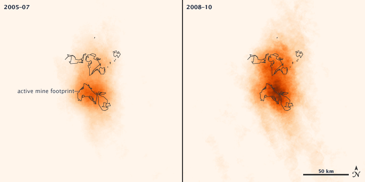
Nitrogen emissions from Athabasca oil sands mining operations, data acquired 2005 - 2010
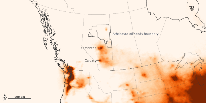
Athabasca Oil Sands mining operations, Nitrogen emissions, data acquired 2005-2010: graphics by NASA Earth Observatory
Using data from a NASA satellite, researchers have found that the emission of pollutants from oil sands mining operations in Canada’s Alberta Province are comparable to the emissions from a large power plant or a moderately sized city. The emissions from the energy-intensive mining effort come from excavators, dump trucks, extraction pumps and wells, and refining facilities where the oil sands are processed.
Oil sands (also known as tar sands) are actually bitumen, a very thick and heavy form of oil that coats grains of sand and other minerals. Once extracted, that asphalt-like oil is partially refined so that it can be transported through pipelines to other refining facilities.
The top two maps above depict the concentration of nitrogen dioxide (NO2) in the air above the main oil sands mining operation along the Athabasca River, as observed from 2005 to 2007 (left) and 2008 to 2010 (right). The lower map shows those emissions in the broader context of the western provinces of Canada and the northern United States from 2005 to 2010. All data were acquired by the Ozone Monitoring Instrument (OMI) on NASA’s Aura satellite.
The oil sands deposit in northwest Alberta covers about 142,200 square kilometers (54,900 square miles). Only 20 percent of the oil sands lie near the surface where they can easily be mined, while the rest of the oil sands are buried more than 75 meters below ground and are extracted by injecting hot water into a well that liquefies the oil for pumping. About 1.8 million barrels of oil were produced daily in 2010 from the Canadian oil sands.
NASA Earth Observatory images created by Jesse Allen, using OMI data provided courtesy of Chris McLinden, Environment Canada and Ronald van der A, KNMI. Mining permit footprints provided courtesy of Matt Hanneman, Global Forest Watch Canada. Caption by Michael Carlowicz, based on reporting from the American Geophysical Union.

Dust hangs in the sunset sky above the Suncor Millennium mine, an open-pit north of Fort McMurray, Alberta: photo by Peter Essick, in The Canadian Oil Boom: Scraping Bottom, from National Geographic, March 2009
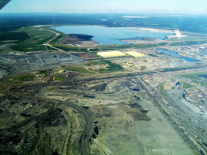
The oil sands industry has utterly transformed this part of northeastern Alberta in just the past few years, with astonishing speed. Where trapline and cabin once were, and the forest, there is now a large open-pit mine. Here Syncrude, Canada's largest oil producer, digs bitumen-laced sand from the ground with electric shovels five stories high, then washes the bitumen off the sand with hot water and sometimes caustic soda. Next to the mine, flames flare from the stacks of an "upgrader," which cracks the tarry bitumen and converts it into Syncrude Sweet Blend, a synthetic crude that travels down a pipeline to refineries in Edmonton, Alberta; Ontario, and the United States. Mildred Lake, meanwhile, is now dwarfed by its neighbor, the Mildred Lake Settling Basin, a four-square-mile lake of toxic mine tailings. The sand dike that contains it is by volume one of the largest dams in the world.
Nor is Syncrude alone. Within a 20-mile radius are a total of six mines that produce nearly three-quarters of a million barrels of synthetic crude oil a day; and more are in the pipeline. Wherever the bitumen layer lies too deep to be strip-mined, the industry melts it "in situ" with copious amounts of steam, so that it can be pumped to the surface. The industry has spent more than $50 billion on construction during the past decade, including some $20 billion in 2008 alone. Before the collapse in oil prices last fall, it was forecasting another $100 billion over the next few years and a doubling of production by 2015, with most of that oil flowing through new pipelines to the U.S. The economic crisis has put many expansion projects on hold, but it has not diminished the long-term prospects for the oil sands. In mid-November, the International Energy Agency released a report forecasting $120-a-barrel oil in 2030 -- a price that would more than justify the effort it takes to get oil from oil sands.
Nowhere on Earth is more earth being moved these days than in the Athabasca Valley. To extract each barrel of oil from a surface mine, the industry must first cut down the forest, then remove an average of two tons of peat and dirt that lie above the oil sands layer, then two tons of the sand itself. It must heat several barrels of water to strip the bitumen from the sand and upgrade it, and afterward it discharges contaminated water into tailings ponds like the one near Mildred Lake. They now cover around 50 square miles. Last April some 500 migrating ducks mistook one of those ponds, at a newer Syncrude mine north of Fort McKay, for a hospitable stopover, landed on its oily surface, and died. The incident stirred international attention -- Greenpeace broke into the Syncrude facility and hoisted a banner of a skull over the pipe discharging tailings, along with a sign that read "World's Dirtiest Oil: Stop the Tar Sands."
The U.S. imports more oil from Canada than from any other nation, about 19 percent of its total foreign supply, and around half of that now comes from the oil sands. Anything that reduces our dependence on Middle Eastern oil, many Americans would say, is a good thing. But clawing and cooking a barrel of crude from the oil sands emits as much as three times more carbon dioxide than letting one gush from the ground in Saudi Arabia. The oil sands are still a tiny part of the world's carbon problem -- they account for less than a tenth of one percent of global CO2 emissions -- but to many environmentalists they are the thin end of the wedge, the first step along a path that could lead to other, even dirtier sources of oil: producing it from oil shale or coal. "Oil sands represent a decision point for North America and the world," says Simon Dyer of the Pembina Institute, a moderate and widely respected Canadian environmental group. "Are we going to get serious about alternative energy, or are we going to go down the unconventional-oil track? The fact that we're willing to move four tons of earth for a single barrel really shows that the world is running out of easy oil."
Robert Kunzig, in The Canadian Oil Boom: Scraping Bottom, from National Geographic, March 2009
Syncrude Canada's base mine, Mildred Lake, Alberta. The yellow structures are the bases of pyramids made of sulphur. It is not economically profitable for Syncrude to sell the sulphur, so it is stockpiled instead. Beyond the mining operation is the tailings pond, contained by what is recognized as the largest dam in the world. The extraction plant is just to the right in this photograph, and most of the mine is to the left: photo by TastyCakes, 4 April 2004; image by Jamitzky, 15 July 2006


No comments:
Post a Comment